
Virtual Orienteering CoursesOrienteering Anytime
MapRun phone app
- Home >
- Information >
- Go Orienteering >
- Virtual Orienteering Courses
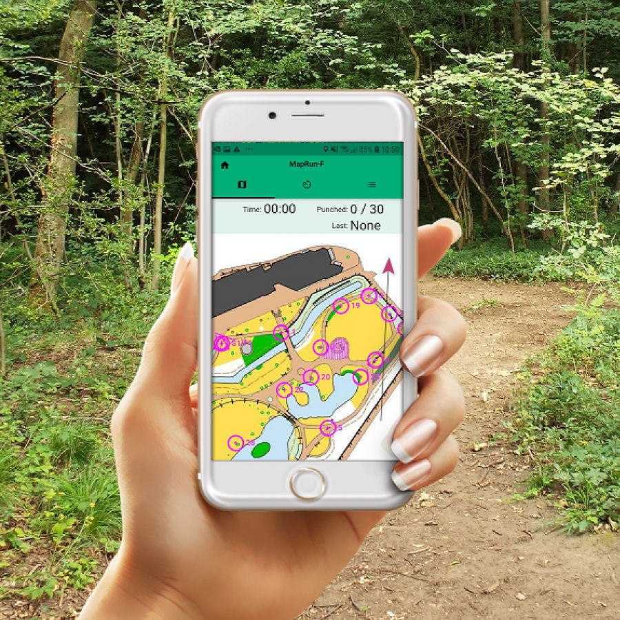
The MapRun orienteering app allows you to take part in “Virtual” orienteering courses using the GPS in your smartphone (or watch) at a time convenient for yourself.
You run a course using either the map on your phone screen or a paper version, and your phone will beep when you reach the correct location of each control.
View all virtual course locations on a map
An Introduction to MapRun
MapRun is a free app that allows you to run a course without any physical infrastructure on the ground (e.g. orienteering timing units). It can be run individually or as an organised club activity. Events are created and stored on the MapRun servers so can be used anytime.
There have been several iterations of the app and MapRun6 is the latest version.
Visit the MapRun website for details and download links of the latest version.
Garmin Connect IQ store for MapRunG to use your Garmin watch instead of a phone.
British Orienteering have also created a new website, www.goorienteering.org.uk which helps you find Permanent and Virtual orienteering courses around the country.
Potteries Orienteering Club have created a youtube video which shows you how to use MapRun at a venue.
In summary :-
The first time you use Maprun :- From your app store, download the application “MapRun6” on your mobile phone and follow instructions to establish identity and give permission for it to access your location data (Settings>Privacy>Location services).
Find an event :- Events are found by searching the ‘MapRun’ app by tapping “Select event” from the main menu. Select “UK” then “Essex” or simply tap “Events near me”. Once you have found your event, you may want to select this before you leave home – so that you can download the map. It is usually easier to also print a paper map, and just use the phone if you need to check your position.
The course :- Almost any type of format is possible; initially we will mainly be using a linear format (like the Summer & Winter series) where you must pass through the control points, in the correct order.
Before you start you will need :-
- A Printout of the map.
- The Location for the start/finish, this is usually same place, marked on map with a triangle/double circle.
- To Consider safety – do your own risk assessment, choose a time when it wont be too busy, use only public roads, paths & open spaces, be aware of other people using the paths, take care in urban areas - look out for traffic, children under 16 to be accompanied by an adult, follow instructions for out of bounds or compulsory crossings.
When you are ready to run :- Open the app ‘MapRun’, navigate to the event and click on “Go to start”.
To Run:- Using your paper map run to the start (marked with a triangle on the map). When you get there the phone will bleep and you have started (phone vibrates, beeps, then gives the incoming message sound). Continue round the course and phone should respond whenever you enter the control circle. If it does not immediately pause a moment (5-10 secs) and it should respond (maybe longer under trees). Finally return to the finish (usually same location as start), once you pass the Finish control, the app will know that you have completed – you do not need to do anything.
Afterwards... Looking at the app you can see your course, results and splits. The results will then be automatically uploaded into a results table so you can compare your run with others.
IMPORTANT
Unless your run is part of a SOS organised event registered with British Orienteering (eg Summer or Winter series) you do MapRun as an individual and you are responsible for your own safety and the safety of others around you hence you are not covered by British Orienteering insurance.
Both the map and the course were created remotely from on-line resources. We cannot vouch for the accuracy of the map (especially narrow alleyways and footpaths) or the safety of control locations or your route. It is your responsibility to keep safe, avoid traffic and maintain social distancing. This is just for fun – do not take risks.
Notes
1) Once you have left the start and registered at least one control point, do NOT pass the Finish, as MapRunF will think you have finished! Therefore do not approach this area again until you are ready to finish. This may affect your route choice.
2) Although you do not need to look at the phone during the run if you do, you can see progress and the last control visited. In order to do this - before you select start on your run, go to ‘Options & Settings’, and ensure that ‘Display your Present Location’ is set to ‘on’. This may help if you cannot find the control using the map.
3) None of the controls are placed in the road – they will all be on the pavement. You should not need to go into the road to get the phone to respond. If a control wont punch (sometimes it takes 5-10 seconds for the GPS to kick-in), then this can be updated afterwards if the track shows you were near the control (the admin can assist with this).
4) It is advisable to be well away from the start when you log-in with your phone to avoid starting before you are ready.
5) If the app stops when the phone goes to sleep then you may need to change the settings.
6) If desired your route can be uploaded into Strava (tap continuation symbol-three bars- on upper right of main screen then “Strava upload”).