
Braintree SouthAnytime Orienteering
Type of course: Virtual Terrain type: Urban & Parkland
Overview
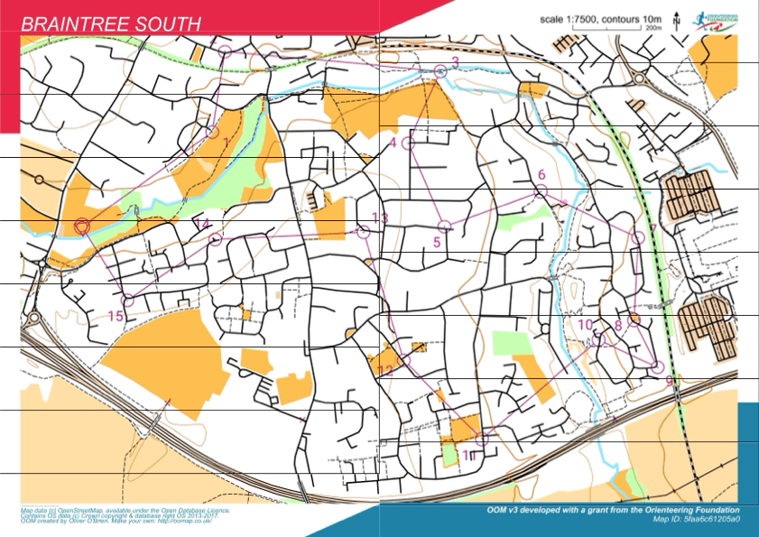
This course was set up especially for MapRun. The course measures 5.2km long from point to point, but the optimum route is closer to 7.5km with 90m of climb.
Location Info
/0.5436,51.8704,12/500x400?access_token=pk.eyJ1IjoicGF1bGZyb3N0IiwiYSI6ImNreHB6M2ttMjBlbnkyd28yNXZzZWJwbGQifQ.fnwThkHVCLn8Nf1UM5_AYw)
Near: Braintree Lat,Lng: 51.8704,0.5436 Postcode: CM7 1YN What3Words: ///suitably.steamed.slap
Open an interactive map in:
GoogleMap -
OpenStreetMap -
BingMap (OS 50k)
Directions / Parking
The Marshalls Park car park is free but fairly small. If full, you could park at a suitable place on the south side of Tortoiseshell Way.
MapRun directory path:
UK/Essex/
Courses available
Braintree SouthLine course, 5.2km,15 controls
Other Information
Location
The start & finish is in Marshalls Park, London Road, Braintree CM7 2AS.
Parking
The Marshalls Park car park is free but fairly small. If full, you could park at a suitable place on the south side of Tortoiseshell Way.
Start and Finish
The ‘Start’ & ‘Finish’ is within the triangle made by three small caged trees about 50m east of the car park.
Controls and Course Length
Course type - Linear, start & finish on Marshalls Park.
Course length 5.2km - 15 controls
OOMap 1:7,500
Terrain
Urban with some trails and open parkland
Safety Notes
Under 16’s must be accompanied by an adult.
Bring clothing and footwear appropriate for the weather conditions. Water will not be provided. Please bring your own to rehydrate.
High visibility clothing is strongly recommended.
As with any street orienteering this requires participants to cross roads and you are asked to take due care and attention at all times.
There may be dog walkers, cyclists and residents using the pavements and footpaths – be aware and give them priority.
Some roads may not have pavements – so take extra care.
Participants take part at their own risk.
Nearest A&E Hospital
Broomfield Hospital, Chelmsford, CM1 7ET
NHS Urgent care search